Day 9 - Friday, 3rd July 2009 - Kununurra Rest Day
Last night, we had a good meal put on by the Hotel Restaurant. It was a bit of a buffet, but there was still a reasonable selection of food on offer. I had their chicken kebabs and some sausages and vegetables. The dessert was also a very nice alternative. It was a very light caramel slice, with fruit salad. A very nice meal that prepared us all very well for our rest day ahead of us.In talking to some of the other riders, I found out that I am not the baby on this ride. On the Rock Ride and the Alice to Darwin ride, I was the youngest by a reasonable margin. On this ride, Renee is the youngest rider, she is only a few years younger than me, and there is also a few other younger riders compared to the other two rides. I would be interested to know what attracted the younger riders to this trip compared to the other ones I have been on.
My day started very early today, despite it being a Rest Day, I had to be up at about 5am, as we were being picked up for our flight at 5:30am. There were two groups leaving at that time, and another leaving at 8am. There were 7 people who were doing the full day tour, myself, Walter, Chris, Fiona, Gill, Kirsten and Lyn. There was also a group of 6 who were doing an early morning flight, but they were due back at about 8:30am or so. Martin, my room mate was in that group, so at least we didn't disturb each other when we both had to get up. At least on the bright side, we had an early sunrise as we have now crossed the boarder and time zone. The sunsets are going to be earlier, but an early sunrise allows us to get away in daylight.
We were introduced to our pilot, who looked very young, and we wandered out to the plane. I had described these in the past as a washing machine with wings, and I think that the description was pretty apt. The wings were above the fuselage, so at least everyone would have a window seat with a good view. Our pilot asked if anyone wanted to sit up front as we had a full plane, and after no one else volunteered I put my hand up. After a few false starts getting the prop turning, we were soon on our way and in the air.
Our first sight of the day was the Ord River Irrigation area. This is a huge area of farmland that is only made possible by the water that is stored in Lake Argyle. They grow a variety of crops, but the main one today is actually Sandalwood. They have in the past grown cotton and sugar, but after the cotton industry was destroyed by the Heliothis caterpillar in 1974, and sugar is no longer grown, probably because it is commercially non-viable. The other crops of note are Mangoes, Grapefruit, Chia ad Melons.
The Ord Stage 2 was apparently announced last night as Kevin Rudd is in town, I am not sure if it is part of the economic stimulus, or just something that has been on the agenda for a while. It will double the total area of the irrigation scheme to 28,000 hectares. Most of the irrigation water is supplied to the land via irrigation channels, so there is going to be a lot of earthworks required to build the system up.
After we left the Ord Irrigation Scheme behind, we headed towards Lake Argyle. We tracked along Spillway River, which was a man made river and it allows water from Lake Argyle to overflow into Lake Kununurra. It was created by blasting through rock, as it was too hard to do by machinery. We crossed over the Dam Wall, which, as is often the case with large water reserves like this, surprisingly small. When it was built, it was one of the most economical Dam's ever built in terms of cost to the amount of water stored. It is a clay, gravel and rock wall, at the time, the cost of using reinforced concrete was simply too high due to the transportation costs. The dam also is the site of Western Australia's largest renewable Energy plant. It is a hydro electric plant that produces all of the power requirements for Kununurra, Wyndham and the Argyle Diamond Mine. Prior to it's construction, 60 million litres of diesel was burned each year to supply the electricity.
The lake itself is massive, it is fairly shallow in a lot of places, but it does get quite deep in some places. It is normally about 23 times larger than Sydney Harbour, but in times of flood, it almost triples in area. It is so vast, that for navigation purposes, it is actually classified as an Inland Sea, which means that any boat wishing to sail on it, has to be registered as an ocean going vessel. It is home to very large number of Fresh Water Crocodiles, but the occasional Salt Water Crocodile has been sighted in it. It is also home to a great number of native fish, and there is a commercial fishing operation in place on it's waters. Barramundi Farming has also been done in it's waters, but the operation has since wound up.
One of the land areas that borders the lake is the Zebra Rock Peninsula. Zebra Rock is a very unique type of sandstone which is made up of multi coloured sand. As a result, the different layers are all different colours and it is reasonably prized. Currently, this site is the worlds only known location of this particular rock.
After we passed over the Southern end of Lake Argyle, we then crossed over Smoke Creek. This is a fairly small creek, but it was the site of the first discovery of Diamonds was made back in 1979. The diamonds found there weren't at the location where they were created, but they had been washed down stream from the diamond pipe. Once the original diamonds had been discovered, the geologists worked their way upstream and located the diamond pipe at what is now the Argyle Diamond Mine.
We crossed over the remains of the Bow River Diamond Mine. This was an alluvial diamond mine that worked by processing the gravel in the area that had been washed downstream from the diamond pipe. It was a very successful operation producing over 1 million carats in it's working life, however, in 2003, the mine was required to close as a result of an issue with Native Title. When it closed, all of it's assets were dismantled and sold.
Our next point of interest was the Lissadell and Texas Downs Cattle Stations. Both of these are located south of Lake Argyle, and are actually quite small as far as Pastoral Leases go. An average Pastoral Lease in the Kimberley averages about 2,500 square kilometres, but these are only about 1,800 square kilometres and 1,600 square kilometres respectively. They are both very isolated, and are virtually impossible to get to in the Wet Season. Only Lissadell has Road Train access at all, so any stock from Texas Downs are mustered to Lissadell cattle yards and loaded from there. The properties share a border on the Bow River, which is fine in the Wet Season, but in the dry, stock are able to move from one property to another. The stock is identified by either a brand or an ear tag, and so when they are mustered, any foreign stock is either returned, or sold with the proceeds going to the other property. Interestingly, any calves born in the wild are considered "clean skins" and the first property to muster them and brand them are then considered the owners.
The next fly over was the Osmond Ranges, they appear as two separate waves about to break over a reef system. They were formed something like 1,800 million years ago, as the result of plate tectonics. They reminded me very heavily of the Western MacDonnell Ranges near Alice Springs. It has been estimated that when they were formed, they were higher than the Himalayas are today, but as they were formed so long ago, they have since been eroded down to their present day size.
We then reached the main goal of our flight, the Bungle Bungle Ranges. These Ranges were virtually unknown until the mid 1980's. It was only when a journalist filmed a documentary in the area on the cattle industry did they finally get launched onto the world stage. Since then, they have become a tourist attraction, but they are still incredibly remote and difficult to access via land. The area was declared a National Park in 1987, and a World Heritage Listed area in 2003.
After a fly over the Eastern and Southern sides, where the beehive formations were clearly evident, we landed at Bellburn airstrip, which was a dirt strip, but it still allowed for a very smooth landing. We all piled out, and Kirsten had had a very rough flight, for her, the landing was just in time, and she started to feel better straight away.
We the found out that our Pilot, James, had been working ridiculous hours for the last few days and was really tired. He had been doing the short flights for the past few days, and that requires something like 14 hour days. He had us on the full day tour today, so he was able to take it a bit easier once we were on the trip.
We met our tour guide for the day, Rick, and our first stop was to the Camp Ground for breakfast. The Camp Ground is a semi permanent structure, and the accommodation is usually tents, but they are very large, and quite well furnished, so they are more like a normal Hotel Room than a tent. The breakfast was excellent. I had my normal cereal, but then I spoiled myself with some of the cooked meal on offer. James joined us for breakfast, and prior to working here, he worked at Banka Banka Station in the Northern Territory as a mustering Pilot. I passed the entrance to it on the way up the Stuart Highway from Alice Springs. He is currently looking at getting into the Air Force. He used to live in Newtown, and he found it a real culture shock moving from Inner City Sydney to out here.
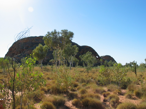
Once we were done with Breakfast, we piled into our transport for the day, and headed round to the South side of the Bungle Bungle ranges. We stopped off a couple of times for a few photo opportunities. The first was at Elephant Rock. These are two of the sandstone domes, which have eroded so that they look like two Elephants. It only occurs when you look at them from a particular angle, but once in that spot, they do look very good. We also had a look at Pindam Wattle, which is the Acacia Species that grows in the area. It is currently in flower, and it is very different to the Wattles that I am used to in NSW. It is called Pindam, as that is the name of the soil that it grows in. They are very localised, and only found in this area.
Our second photo showed some of the beehives that make up the Bungle Bungle Ranges. Even though we were at a distance to them, they were pretty amazing, we just couldn't wait to get even closer. It was amazing to see the stripes on them, alternating between orange and black. The orange stripes are caused by iron oxide, or rust, while the black is from cyanobacteria, one of the oldest lifeforms on Earth. In both cases, the layer is hard, but only very thin, if it is damaged, it takes up to 10 years to reform, during which time the underlying sandstone is exposed, and it usually gets very weathered.
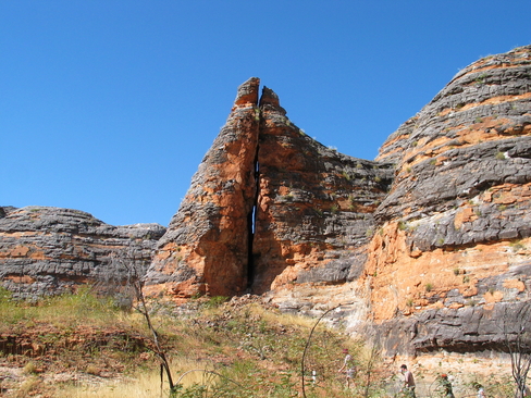
We then jumped back on our bus to the start of Piccaninny Creek. We were doing a walk to the lookout, and then into Cathedral Gorge. Both were relatively short walks, but with the amount of sightseeing, they did take a while. The lookout was to the overlooked the South and while it didn't show all of the domes in their glory, it was still an amazing view. Just shy of the lookout was a cracked dome. The area is riddled with fault lines, and this one goes right through one of the domes, so there is a crack through the middle of it, it is possible to see right through it.
After the lookout we trekked back to Piccaninny Creek, and then towards Cathedral Gorge. On the way there, we deviated slightly and visited a smaller gorge. Often, when the water is flowing, it will cause small eddies, these sometimes will start tossing river pebbles around, and these would then bore a hole in the soft sandstone. Some where quite small, and others a lot larger. One at the base of a waterfall was probably about 5 metres deep. Apparently, a large python fell down there at the end of the wet season, he slowly got thinner and thinner, but there was no sign of him when we visited. Either he got thin enough to escape, or he died down there.
We then moved onto Cathedral Gorge Amphitheatre. This is at the base of a giant waterfall, so it has carved out an enormous pit at the bottom. There was a small pool of water, but it looked very stagnant, so I wasn't even prepared to touch it. It was amazing at the size, and I wonder how long it had been forming for. As nice as it was, it was really difficult to get a good photograph, there simply wasn't enough light, and because of the size, the camera flash wasn't sufficient. We spent about 20 minutes there, just wandering around and looking at it from different angles. It was well shaded, but because of the heat from the sun, it wasn't too cold.
We headed back out, and after a brief toilet stop, we jumped back on the bus to head around to the North side of the ranges. On the way out, we passed a limestone outcrop, that apparently runs an incredible distance. I think that it is what forms the China Wall near Halls Creek. We stopped at one point for photographs again, and someone on the tour commented about it not being as "good" as the South. I remarked that it was just different. The North side contains a lot more pebbles in it's conglomerate, and it has eroded differently compared to the South.
We headed on round to the Echidna Chasm car park, and we grabbed our Lunch bags and headed in. On the way, we passed a Bower Birds Bower. This particular species collects rocks, and stones, but at the end of the day, he is after anything white, so small bones also do the job. He wasn't in residence, so either mating season was over, or he was scared off by us.
We soon entered the Chasm proper, and it reminded me a lot of Standley Chasm in the Western MacDonnell Ranges near Alice Springs. The walls rose about 200 metres straight up on either side, and it changed in width from only a metre or two, up to about 5 metres. You could see the different strata in the walls as they were laid down by different floods in the past. The Aboriginal Legend talks about a fight between the Echidna and the Cockatoo, the Echidna was trying to escape by borrowing down, hence the scratch marks in the walls, while the Cockatoo was ripping his spines out and tossing them away, which formed the Livistona Fan Palm. The Fan Palm is only found in this area, and it is usually clinging to a rock face in some impossible location.
We reached what we thought was the end of the line, but I walked on to the end of the wall, and it kept going around the corner. I wandered up a short way, and then came back as we were settling down for lunch. It was a very nice sandwich with home made bread from the camp site. Despite there being a few benches, there were enough rocks around that we all pretty much found one to our liking and sat there. We discussed with our guide about the Intervention and the plight of the Aboriginal People in the area. It is always interesting to hear about the problem from people in the area, and how well the solution is working. It gives a different perspective compared to what we are hearing from Canberra and the media.
We then headed to the very end of the Chasm, Rick our guide, told us that there may be Green Tree Frogs right at the end, but there were none in evidence when we got there. In some place, there were boulders which had tumbled down into the Gorge, sometimes making it to the bottom, and sometimes getting wedged halfway down. I also saw some spider webs, but they were formed like a nest of some description, very densely woven over a small crack in the stone. I didn't see any spiders in residence, so I don't know how big or small they were, let alone what type they were.
We headed back out, and on the way, I passed a German chap who had met Phil and Susan in Switzerland a few months ago, he asked me to pass his card along to them. Before getting back to the bus, we had one final stop, which was a lookout viewing the Southern side of the Osmond Ranges. It is still hard to believe that they were once giant mountains, and they have been weathered down over millions of years. Goes to show just how insignificant we are.
We then headed back to the Airstrip, and while we were supposed to get Afternoon Tea, we had time against us, so we had to skip it. James, our pilot was already back there, and so we had to jump on the plane and wait for take-off clearance. While we were waiting, Kirsten who was now in the co-pilots seat, was shown the basics of how the plane controls worked, something he never showed me. I mustn't have had the legs for it.
Once back in the air, we did a bit more flying over the Bungle Bungle Ranges showing some of the chasms within it, as well as what is believed to be a meteor impact crater in the middle. Then it was North back towards Kununurra.
The highlight of our return flight was the Argyle Diamond Mine, the largest diamond mine in the world. The original company to find diamonds was CRA in 1979, the only problem was that they didn't have the mining lease at the time. They tried to keep it secret until the lease was up for renewal, but word got out. In a brilliant move, CRA hired nearly every 4WD, Helicopter and light aircraft, and did a lot of wandering around El Questro, about 100km North West of the where the diamond mine actually is. This threw everyone else off the scent, so when Afro-West, the company with the lease decided not to renew it, CRA was in court the next day, got the lease, and then announced the worlds largest diamond mind.
The mine produces about one-fifth to one-quarter of the worlds diamonds by weight which is an average of about 20 million carats, but only a very small fraction of these are of gem quality. They are mainly brown and pink diamonds which are found. Rio Tinto, the current owners, have a very clever way of ensuring that the price of Pink Diamonds are artificially inflated. They tour the world each year showcasing the diamonds, and any prospective buyers enter a bid on a lot, and only one bid, without knowing what anyone else has bid. Then the highest bidder wins the lot. This forces the buyers to probably bid higher than they are actually worth to ensure that they get what they are after.
Ironically, while Kununurra is seen as a place to buy diamonds, any found in the Argyle Diamond Mine are sent to Perth for cutting and polishing, so any diamonds in Kununurra get there via Perth. The Argyle Diamond Mine is also home to the Southern Hemisphere's largest private airstrip, large enough to handle 737's. It wasn't well thought out though, as it rests on an area that has a lot of diamonds underneath it. So at some point, it will have to be relocated.
We had a final flight back over Lake Argyle, the Ord irrigation scheme, and we finally touched down in Kununurra again. We landed shortly before Sunset, and we were bused back to the Hotel. We had been asking for a lot of the day about somewhere to eat, and while a suggestion was made, we felt that it was too far from the Hotel, so we felt that it was best to just eat at the Hotel Restaurant.
We got back at about 5:30pm, and we decided to regroup in the Hotel Bar at 6:30pm, so enough time for a bit of a relax and a shower. All up, for a rest day, it was pretty full. I am really glad that I did the full day tour, despite not giving me much time around Kununurra, it did allow me to see a lot of the Bungle Bungle Ranges, somewhere which is truly spectacular. It was also great to see Lake Argyle, the Osmond Ranges, and the Argyle Diamond Mine. Considering the remoteness of the Bungle Bungle Ranges, flying in is a very good option. It takes about 4 to 5 hours to drive it from Kununurra, and the last 50km is on dirt road which isn't in the best condition. I would recommend to anyone in Kununurra to take a flight over the Ranges, even if you don't touch down, it is worth it.
The problem I had with the day wasn't with the flight, or any of the places that we visited, it was with my camera, and the number of photos that I took. I took about 500 odd photos on the day. Most were junk. In the air, it was very hazy, and while what we were looking at was great, the camera didn't capture it all that well because of the haze, and at 4x zoom, the photos came out a bit soft. In some of the gorges, there were light problems, which I think would have challenged most cameras. So the shots either came out overexposed, or blurry because of slow shutter speeds. Considering that my camera is now over 6 years old, and the LCD is no longer working, I think that an upgrade may be in the pipeline.
Images
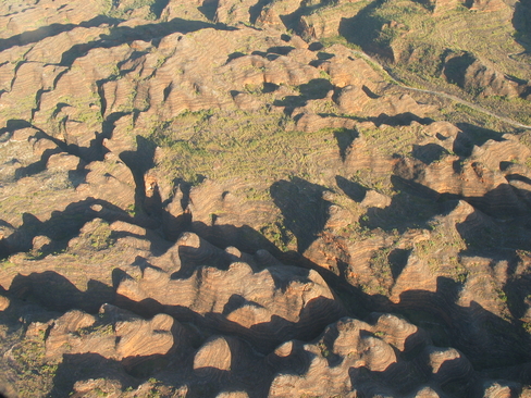
The Bungle Bungle Ranges
The beehive domes of the Bungle Bungle Ranges
There are many fault lines through the Ranges, sometimes forming cracks like this one
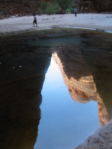
The pool of water at the end of the Cathedral Gorge
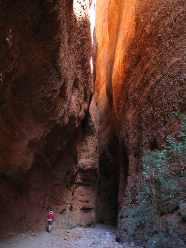
Walking through Echidna Chasm
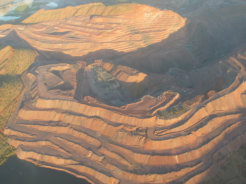
Argyle Diamond Mine, the worlds largest diamond mine
Click Here for more Photos from Day 9.