Day 9 - Tuesday, 16th June 2009 - Katherine Rest Day
Each night at briefing on this trip, a rider has been given an award for cycling well as a member of the group. It doesn't go to the strongest rider, just someone who has worked well with the group for that day, or has done hard yakka to get to the end. I was lucky enough to be that cyclist last night, first because I rode with Fiona all morning, and helped get her to Morning Tea pretty much on time when we picked the pace up, but also, because I often help Phil to pack up a bit at the end of each break. It only takes a few minutes, and it makes their job just a little bit easier. Plus it allows the other riders to get a few minutes lead on me for when I get going. The prize has varied between a small shoulder bag, to books, and tonight I got a mouse mat with Aboriginal Dot Art.We had a nice meal last night, there was the choice of either a battered Barramundi with a seeded mustard sauce, or some roasted lamb cutlets in a rack. I opted for the Barramundi, but as two of our riders had gone to a local Rotary Meeting, it meant that there were two spare meals. These were divvied up between the remaining people, and I did have some of the lamb. Both of them were excellent meals. For desert, there was fruit pudding (ala Yuletide) or a meringue. I didn't feel like anything heavy so I went with the meringue.
Despite today being a rest day, we had breakfast at 7am, as Phil was hoping to get us away at 7:30am for those who were going Canoeing at Katherine Gorge. All but Pat, who was meeting a friend, were going out there, so we all piled into two of the support vehicles and got driven the 30 odd kilometres out to Katherine Gorge. I was planning on doing some walking around the area with Phil and Susan, but I did watch everyone get started in their canoes. There were a few funny incidents, as they were two man canoes. One team had the person on the front paddling forwards on the right, and the person on the back paddling backwards on the right. They didn't seem to be going very far quickly.
In the end they all got away, and Phil, Susan and I worked out a walk that we could do. We could climb the escarpment up to a lookout at the top, and then return via a longer route. There was a longer walk that I wanted to do, and despite the time that they listed, I felt that it was pretty generous and that I wouldn't have any problems covering the distance in the time that we had.
We set off, an there was a pretty steep start to the walk, I commented that I thought that the walk was going to be the relaxing option, but maybe the canoeing would have been. When we got to the top, the canoeists were already out of sight, but as they were asked to hug the right bank (the side we were on), it would have been difficult to see them from where we were. After a few minutes sight seeing, we set off on the long route return. There were some water tanks and a filtration system that probably provides water for the Tourist Centre, and we met a few other walkers. They asked about where we had come from, and where we were trying to get to. They were interested in doing a similar walk to me, but they were unable to find the turn off. We hadn't passed it, so there was a certain amount of confusion about how to get on the Southern Walks.
I went bush bashing, trying to see if there was a trail, as according to their map, there was a water point near where the trails all separated, which is where we believed we where. When I got back, Phil and Susan had pressed on, and after a bit more confusion, we managed to orientate ourselves on the map. It turned out that the water filtration plant, wasn't the tap that was indicated on their map. We started backtracking, and finally found where the trails split up. The junction had a map of the walks, but no signs indicating which way to go for each of them. It was only on a careful inspection that you could see the blue triangle signs indicating a trail a bit of a way up the path. It seemed that the first one had been removed.
We set off, and I was talking to the couple who were with me, John and Deb. They were touring around Australia, and while they theoretically lived in Perth, they hadn't lived there for 5 years, having been over in Malta and Europe (John was Maltese) for the last 4 years or so, and they had spent the last 10 months touring around Australia, with the idea of spending another 5 months before finally getting back to Perth.
On our way out, we passed a couple of older walkers who were making their way back after they had trekked out to the furthest point for the last 4 days. They were on their 5th day of walking. They weren't covering huge distances, and while it is strictly winter, it was still forecast to get into the high twenties today. Their policy was to get up early before sunrise, and as soon as they could see where they were going, set off and walk for 5 or 6 hours. Then set up camp in the afternoon.
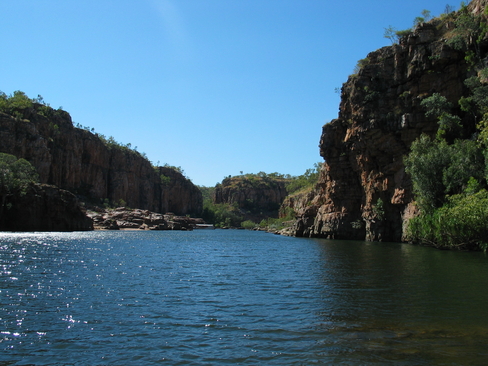
A lot of the surface that we were walking on seemed to be a dry water channel. It was reasonable sized rocks, so you had t be careful where you were putting your feet. It would be very easy to roll an ankle. I was glad that I had decent hiking boots on. We made our way fairly briskly to the end of the walk, where we could either go to Pat's Lookout, or down to the Katherine River. We originally went out to Pat's Lookout, and I was able to see some Canonists out o the water. It was too far to see if they were All Trails Riders, but it was a fair guess. It was really scenic up there, and it was a chance to really see what Katherine Gorge was all about. I had only got as far as the end of Gorge 1, and there are something like 7 or 8 at least, so it is a very extensive network.
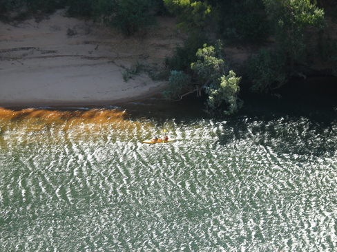
I set off on my own, as time was starting to get a bit low, so I set off down to the river bank. The sign only said that it was 450m away, but it was a round about route, and it did involve some fairly serious rock scrambling. There was a very small waterfall feeding a small pond on the way down that would be pretty amazing in the wet when it is in full flow. But you probably wouldn't be allowed down there due to the amount of water coming down. I made it to the bottom, and again was very impressed with the views that were on offer. The canonists had all moved out of sight, and I had about an hour to get back to the Visitors Centre. I knew that it would be tight, so I had to Power Walk to get there on time. First though, I had to get up the Escarpment, so that involved some pretty strenuous walking. So much for my rest day.
Luckily, although I only had one water bottle with me, I had filled it up twice previously, and I would pass one of those points on my return leg, so water was not going to be an issue. I had applied sunscreen as I didn't want to get burnt, so I was just hoping that my legs would hold out on the way back. I was a bit annoyed that I had to rush, for two reasons, one, I wanted to have a bit of a rest day, but also, I wanted to take the time to appreciate what I was walking through, it is a bit hard to do that when all you can look at is where you are putting your feet to avoid twisting an ankle.
Once I made it back to the main track, I did ease up, thinking that I was quite close, but I only made it back to the visitors centre at about 11:50am. The canoeists had already returned and were getting themselves some lunch. I felt that that was an excellent idea, and joined them. It seemed that the gannets had already been through, as there wasn't a lot of choice left. There were a reasonable number of sandwiches, but as long as you wanted Curried Egg and Lettuce you were fine. I did manage to find enough to eat though, so I wasn't about to go hungry.
After some lunch, we had a wander around the visitors centre looking at the cultural information on offer as well as information on the formation of Katherine Gorge and the flora and fauna that was in the area. There were also some pictures of the floods of the area in the late 90's and in 2006. The amount of water coming through was colossal. Considering the height of the Tourist Centre above the river level, and it was lapping at it's foundations, you would be measuring the change in close to 10m.
I got on the bus that headed back to the Hotel at 1:15pm. There was an option to go to an Art Gallery on the way back, but I wasn't particularly fussed. I had a few things that I wanted to do back at the Hotel and in Katherine, and as much as I wanted to see what was around, I needed to make sure that I was ready for more cycling tomorrow.
I took a wander around town, as well as into a Camping Store, as I didn't bring a Cup along for the Darwin to Broome Ride. I needed one as we are camping out on 3 nights. While it is something that I could have done later, I felt that it was good to get sorted out now. When I was in the shop, there was a guy from a nearby Station (if you can call 100km nearby) who was buying up a lot of ammunition. They were starting to get a lot of wild pigs and water buffalo problems, and for them, it was the way that they dealt with it. I then took a bit of a walk up the main street to see what was on offer, and I purchased a T-Shirt for my nephew. After that it was back to the Hotel to get my website all up to date for everyone who has been following my adventures.
We need to sort out our own dinner for tonight. One option that was presented was a Restaurant that does Bush Tucker. I was interested, but it was $45/person, and I think that the price put a lot of the other people off. I am sure that we will pretty much all end up together somewhere.
Tomorrow is an interesting day. There is only about 90km to Pine Creek, but there is an optional 38km diversion to visit Edith Falls. I am not sure if I am going to ride out there, or catch the bus. I will see how I feel at the time. Right now, I am doing my best to avoid thinking about the next few days. There are only 3 more days until we reach Darwin and this ride comes to an end. For me, it is the end of one adventure, and the start of my stay in Darwin, until I return back to Katherine and head towards Broome, but it is always sad when one of these rides ends. We have been a close group on this ride, as there is only 12 riders and 4 staff. It didn't take long before we all knew each other and were having a great time.
Images
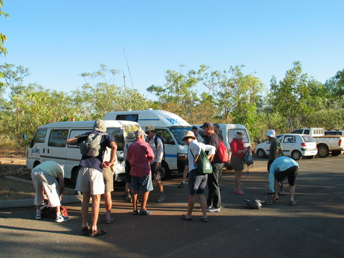
Everyone getting ready for their canoe trip.
I'm ready, what's keeping everyone else?
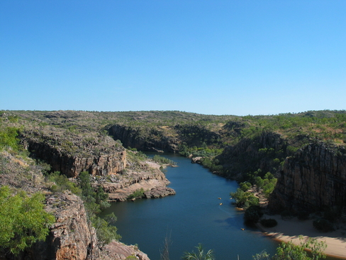
View from Pat's Lookout, the Yellow Dots are Canoes
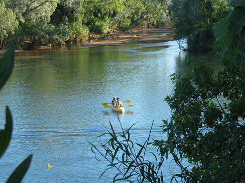
John and Fiona paddling back to home base
Back at River Level, looking at the end of Gorge 1
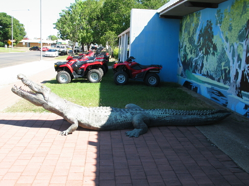
A model Saltie outside Rod and Rifle, at least you knew what they were selling
Click Here for more Photos from Day 9.